3 October, 2024
The need for more accurate geographical coordinates for earth stations in SpaceCap


The International Telecommunication Union (ITU) Radiocommunication Sector (ITU-R) plays an important role in the global management of the radio-frequency spectrum and satellite orbits to ensure the interference-free operation of radiocommunication systems. This is achieved by managing the detailed coordination and recording procedures for space stations and earth stations used for various services.
These procedures require satellite operators to submit space station and earth station filings through their respective administrations for advance publication, coordination, notification, and recording. The submissions are created using a software tool called SpaceCap, which allows users to view, create, and edit satellite filings in an electronic format.
For an earth station filing, geographical coordinates are mandatory in SpaceCap. According to Appendix 4 of the radio regulations, under the general characteristics of the satellite network or system, earth station, or radio astronomy station, for a notification or coordination of an earth station (including notification under Appendices 30A or 30B), the geographical coordinates of each transmitting or receiving antenna site constituting the station (latitude and longitude in degrees and minutes) should be provided. For a specific earth station, meanwhile, seconds are to be provided if the coordination area of the earth station overlaps the territory of another administration.


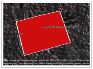
However, the SpaceCap input format, as shown in the figure above, has a limitation (this includes the most recent version of SpaceCap before publication, Version v9.1.37). SpaceCap only accepts integers for the minutes and seconds fields of geographical coordinates for earth station filings. This means that the accuracy of the coordinates is limited to approximately one second in latitude and longitude, which corresponds to a distance of about 30m and 24m at the equator and less at higher latitudes. This inaccuracy can have significant implications for the coordination and protection of earth stations.
For example, consider two earth stations that are located 10m apart, but their latitude and/or longitude differ by one second due to rounding. This creates unnecessary difficulty in licensing, protection, and coordination, as it may not be possible to distinguish the two earth stations using the information in SpaceCap. Moreover, if an earth station is located near the border of another country and its coordinates are rounded up or down to the nearest second, its coordination area may appear to be overlapping with the territory of another country. This will trigger unnecessary coordination procedures that could have been avoided if the coordinates were more accurate.
These scenarios are not hypothetical. We recently had a filing rejected by an administration because the earth station was located in an antenna farm, alongside many others. Since the antennas were less than 30m apart, each antenna could not be pinpointed using the coordinates allowed on SpaceCap. Hence, the administration was reluctant to accept the filing as the location provided points to another station that is not the subject of the earth station filing. This caused unnecessary delays in the coordination and notification process but was later resolved by providing supplementary information to clarify the exact location of the earth station.
However, this solution not only adds to the administrative burden and complexity of the procedure but also affects the accuracy of the Appendix 7 contour calculation, which determines the earth station’s coordination area. GIBC (Graphical Interface for Batch Calculations), the ITU software used to calculate the coordination area for earth stations, takes the geographical coordinates from the earth station filing. This means that the resulting coordination area will retain the inaccurate geographical coordinates, even though a correction is provided as supplementary information.
To address this problem, we propose an update to SpaceCap that will allow the software to accept fractions of seconds and minutes in the geographical coordinate field. Accepting up to a tenth of a minute or second will increase the accuracy of the geographical coordinates tenfold. This corresponds to an increase in the accuracy of an earth station’s geographical coordinates to 3m at the equator and less at higher latitudes. The proposed solution would not only improve the accuracy and reliability of the coordinates of earth stations in the ITU databases but also enhance the efficiency and transparency of the advanced publication, notification, and coordination procedures.
Therefore, in accordance with resolves 1 of Resolutions 86 (Rev.WRC-07):
“to consider any proposals which deal with deficiencies and improvements in the advance publication, coordination, notification and recording procedures of the Radio Regulations for frequency assignments pertaining to space services which have either been identified by the Board and included in the Rules of Procedure or which have been identified by administrations or by the Radiocommunication Bureau, as appropriate”.
We urge administrations and operators in the satellite industry to consider submitting a proposal to request for an increase in the accuracy of geographical coordinates in SpaceCap and other ITU software applications. This could be raised as a topic of discussion under the World Radiocommunication Conference 2027 (WRC-27) Agenda Item (AI) 7, in accordance with ITU Resolution 86 (Rev.WRC-07). The responsible group for AI 7 is Working Party (WP) 4A, which is currently open to contributions ahead of its next meeting in October 2024.


